The loss of the NOAA Northeast Fisheries Science Center “HabCam” (short for Habitat Mapping Camera) during a recent scallop survey has raised concerns from some groups about the transparency of the survey process.
The sea scallop survey of the U.S. Northeast scallop fishery performed by the Northeast Fisheries Science Center uses a combination of dredging and the HabCam to determine the densities of scallops at survey stations in the areas that are typically fished. Data from both the camera and the dredge, as well as data from a number of other surveys performed by colleges and other institutions, are used to create a model that the various government organizations managing the resource – including the New England Fisheries Management Council (NEFMC) – use to set quotas for the coming year.
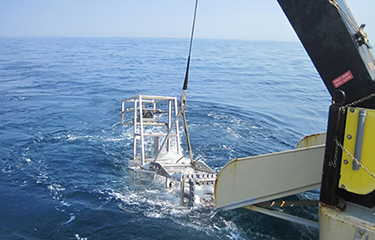
The HabCam is towed behind the research vessel on a long tether and is used to take detailed photos of the sea floor in order to get ideas on how dense and mature the scallop population is. According to the science center, during a survey of the Great South Channel on 6 June the HabCam struck an uncharted object in 130 feet of water, severing the tow cable.
“The weak link in the tow cable broke, as intended when tension is too great,” the science center wrote in a release. “This limits damage to both the instrument and the ship’s tow winch. The HabCam was separated from the ship, but a sound-emitting locator attached to it signaled its location.”
The crew of the ship, the Hugh R. Sharp, continued to conduct dredge surveys while recovery operations commenced on the camera. It was recovered on 10 June, and initially was working as normal, but eventually developed electrical problems that forced the survey to be conducted via dredge only.
Whether the electrical failure was caused by the impact, or something else, is unknown, Teri Frady, with the NEFSC, told SeafoodSource. She added that weather problems also contributed to the inability to complete some of the surveys.
“The majority of the work was done, but we did lose a section of the Great South Channel [survey] that we had planned to do during that last week,” she said.
According to Frady, the rock that the HabCam struck was large enough that once spotted, there wasn’t enough time to avoid it.
“The rock was big, and it’s not charted because it’s in the channel, so it’s not really a hazard to navigation,” she said. “Once you’re on it, you can’t get the winch to operate quickly enough.”
It isn’t the first time that the HabCam has struck something and been lost; a similar incident occurred in 2016. After that incident, the science center added additional precautions to the camera, according to Frady. Those improvements include an audio beacon that made finding the device much easier, and reinforcements to protect the camera in the event of a collision.
The Fisheries Survival Fund, which advocate for the scallop fishery, said that the loss of the HabCam will likely disrupt the survey, which could have an affect on quotas.
“The scallop fishery is very data-intensive in terms of how it is managed; We use a lot of surveys because we make virtually real-time adjustments,” David Frulla, who represents the Fisheries Survival Fund, told SeafoodSource.
However, the greatest concern is related to the way that members of the industry, and the NEFMC, learned about the loss of the camera.
“We sort of learned about it, and many of the council staff learned about it, off-hand at the council meeting,” Frulla said. “It was like pulling teeth to get the information about what happened.”
The fund is advocating for greater transparency regarding any issues regarding the HabCam, or surveys in general. It is also calling for a contingency plan for when the HabCam suffers an incident, considering it has already happened twice in the last three years.
Frulla added that the open sharing of information and intensive data collection is part of what makes the scallop fishery so successful. The Atlantic sea scallop fishery is one of the most valuable in the U.S., estimated to be worth USD 440 million (EUR 393 million) annually.
“We have a variety of data sources, and really, I would say as good a snapshot as anybody in the country, if not the world, of what the resource looks like year to year,” he said. Transparency has also given members of the industry a lot of faith in the survey and quota management process, Frulla said.
The exact details of how large the impact the loss of the HabCam will have on the survey will be revealed in the next few days, Frady said. She added that the science center announced the loss as soon as they had details of what happened.
“We can always make an announcement sooner, but there wasn’t too much to know, other that we knew we had lost it,” she said.
She did confirm that some of the HabCam survey stations could not be completed, but that all of the dredging survey stations were completed. There is a chance that the incomplete HabCam survey stations could be completed by another survey from another organization – the University of Massachusetts, the Coonamesset Farm Foundation, and more also survey scallops – but nothing can be confirmed.
Janice Plante, a public affairs officer for the NEFMC, told SeafoodSource that all surveys are important for the council’s management of resources.
“The surveys tell us where we have concentrations of scallops, the surveys help monitor incoming year classes,” she said. “The surveys are extremely important to the council, because they’re at the core to our process to set annual specifications for the fishery.”
However, Plante said that the council has no comment on whether the loss of the HabCam will affect the survey’s accuracy or any council decisions.
Frulla also added that the fund understands that the fishery is certainly in no danger of complete closure, but that there are still concerns over transparency.
“There’s got to be a better way to share information,” Frulla said. “We want it to be as strong as possible, again, that’s why we get a little frustrated when we don’t know the details.”